Mynd:ChiPitts area.png
Jump to navigation
Jump to search
Það er engin hærri upplausn til.
ChiPitts_area.png (300 × 300 mynddílar, skráarstærð: 23 KB, MIME-gerð: image/png)
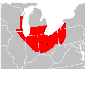
| Lýsing | en:ChiPitts (Chicago-Pittsburg) megalopolis area in red. Major cities are shown with a black dot |
| Uppruni | Image made from BlankMap-USA-states.PNG, modified to show approximate boundaries of the ChiPitts |
| Höfundarréttarhafi | Ctjf83 |
| Aðrar útgáfur | en:Image:ChiPitts_area.png |
| |
This work has been released into the public domain by its author, Ctjf83, at the enska Wikipedia project. This applies worldwide. In case this is not legally possible: |
Breytingaskrá skjals
Smelltu á dagsetningu eða tímasetningu til að sjá hvernig hún leit þá út.
| Dagsetning/Tími | Smámynd | Víddir | Notandi | Athugasemd | |
|---|---|---|---|---|---|
| núverandi | 14. mars 2008 kl. 14:27 | | 300 × 300 (23 KB) | Pierre cb | {{Information |Description=en:ChiPitts megalopolis area in red. Major cities are shown with a black dot |Source=Image made from [http://commons.wikimedia.org/wiki/Image:BlankMap-USA-states.PNG BlankMap-USA-states.PNG], modified to show approximate b |
Skráartenglar
Eftirfarandi síða notar þessa skrá: