Mynd:Convention du Mètre.png
Jump to navigation
Jump to search

Stærð þessarar forskoðunar: 800 × 351 mynddílar Aðrar upplausnir: 320 × 140 mynddílar | 640 × 281 mynddílar | 1.425 × 625 mynddílar.
Upphafleg skrá (1.425 × 625 mynddílar, skráarstærð: 39 KB, MIME-gerð: image/png)

|
This file has been superseded by Metre Convention Signatories.svg. It is recommended to use the other file. Please note that deleting superseded images requires consent.
|

|
File:Metre Convention Signatories.svg is a vector version of this file. It should be used in place of this PNG file.
File:Convention du Mètre.png → File:Metre Convention Signatories.svg
For more information, see Help:SVG. |
 |
Lýsing
| Lýsing |
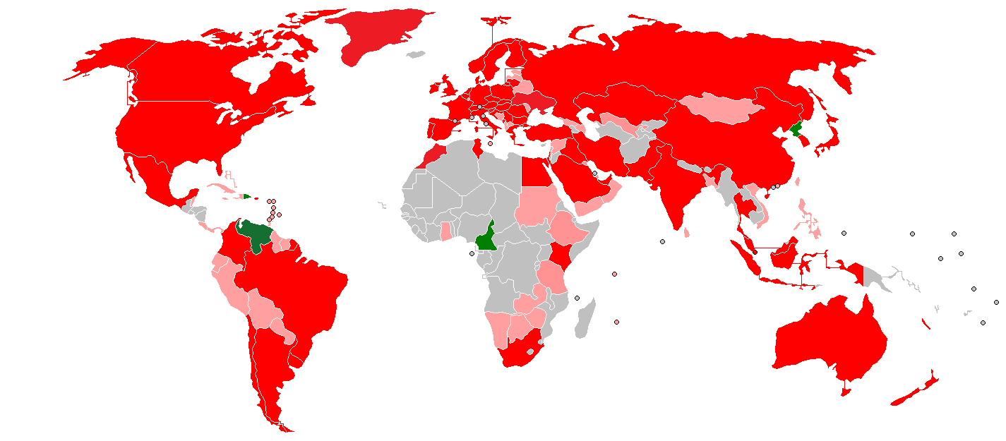
English: Metre Convention signatories:
Français : Signataires de la convention du mètre:
États membres États associés Anciens membres
|
| Dagsetning | (UTC) |
| Uppruni | |
| Höfundarréttarhafi |
|
Leyfisupplýsingar:
I, the copyright holder of this work, hereby publish it under the following licenses:
| Þessi skrá er með Creative Commons Tilvísun-DeilaEins 3.0 Óstaðfært notkunarleyfi. | ||
| ||
| This licensing tag was added to this file as part of the GFDL licensing update. |

|
Gefið er leyfi til að afrita, dreifa og/eða breyta þessu skjali samkvæmt Frjálsa GNU Free Documentation License, útgáfu 1.2 eða nýrri, sem gefið er út af Frjálsu hugbúnaðarstofnuninni með engum breytingum þar á. Afrit af leyfinu er innifalið í kaflanum GNU Free Documentation License. |
Þú mátt velja notkunarleyfi að eigin vali.
Original upload log
This image is a derivative work of the following images:
- File:BlankMap-World-v3.png licensed with Cc-by-sa-3.0-migrated, GFDL
- 2011-07-29T11:59:44Z Hoshie 1425x625 (54717 Bytes) added South Sudan
- 2010-10-09T15:52:02Z LX 1425x625 (30516 Bytes) Reverted sockpuppet edits to version as of 22:21, 20 March 2009
- 2010-10-02T06:16:33Z Lartyo 1425x625 (30447 Bytes) Deleted lines, as for Norway-Svalbard. And East Europe.
- 2010-10-02T06:13:18Z Lartyo 1425x625 (30532 Bytes) We need Kosovo, don't revert.
- 2009-03-20T22:21:00Z Avala 1425x625 (30516 Bytes) what does this map represent? world as the majority sees it or a file that is unnusable in most of the projects
- 2009-03-08T17:12:59Z Cradel 1425x625 (30532 Bytes) Reverted to version as of 20:23, 25 February 2008
- 2008-11-20T01:02:21Z Tocino 1425x625 (30516 Bytes) Reverted to version as of 20:06, 25 February 2008
- 2008-02-25T20:23:45Z Nightstallion 1425x625 (30532 Bytes) Reverted to version as of :, 0 <>
- 2008-02-25T20:06:17Z Cp6 1425x625 (30516 Bytes) Reverted to version as of :, 0 <>
- 2008-02-25T11:15:33Z Nightstallion 1425x625 (30532 Bytes) Reverted to version as of :, 0 <>
- 2008-02-24T13:38:40Z Cp6 1425x625 (30516 Bytes) Reverted to version as of :, 0 <>
- 2008-02-24T12:44:47Z Nightstallion 1425x625 (30532 Bytes) Reverted to version as of :, 0 <>
- 2008-02-23T22:28:14Z Cp6 1425x625 (30516 Bytes) No OVERWRITING, look disc
- 2008-02-23T10:53:53Z Nightstallion 1425x625 (30532 Bytes) Reverted to version as of :, 0 <>
- 2008-02-22T22:11:18Z Cp6 1425x625 (30516 Bytes) It isn't internationally recognized, look [[Image:Kosovo relations.png]]
- 2008-02-18T23:14:47Z Hoshie 1425x625 (30532 Bytes) Added Kosovo since it has been internationally recognized.
- 2007-11-10T04:05:16Z Hoshie 1425x625 (30516 Bytes) re-drew Cabinda (Angola); under same lic. as before.
- 2007-11-05T04:56:09Z Wiz9999 1425x625 (30584 Bytes) Corrected proportions to correlate with BlankMap-World.png
- 2007-01-26T17:08:20Z David Levy 1350x625 (14490 Bytes) better compression
- 2006-12-08T06:20:07Z Hoshie 1350x625 (30100 Bytes) Added Cabinda. Under same license as original
- 2006-06-05T02:37:46Z Roke 1350x625 (30144 Bytes) montenegro independent
- 2006-03-28T06:25:43Z David Levy 1350x625 (14680 Bytes) better compression
- 2006-03-28T02:41:22Z E Pluribus Anthony 1357x628 (28783 Bytes) World map: blank, with borders; circular microstates; interlined (2006)
- 2006-03-26T20:56:49Z David Levy 1350x625 (14714 Bytes) better compression
- 2006-03-25T13:06:51Z E Pluribus Anthony 1357x628 (28860 Bytes) World map: blank, with borders; circular microstates; interlined (2006)
- 2006-02-24T23:59:44Z E Pluribus Anthony 1357x628 (47414 Bytes) Reverted to earlier revision
- 2006-02-22T20:36:57Z Huhsunqu 1357x628 (47406 Bytes)
- 2006-02-22T02:15:36Z Roke 1357x628 (47414 Bytes) This is a version of w:Image:BlankMap-World-v2.png map on wikipedia. This map is only designed to show countries for use on statistical information to be converted into maps where it takes a long time to add the information f
Uploaded with derivativeFX

|
The categories of this image need checking. You can do so here.
|
Breytingaskrá skjals
Smelltu á dagsetningu eða tímasetningu til að sjá hvernig hún leit þá út.
| Dagsetning/Tími | Smámynd | Víddir | Notandi | Athugasemd | |
|---|---|---|---|---|---|
| núverandi | 5. nóvember 2019 kl. 16:18 | | 1.425 × 625 (39 KB) | Martinvl | Painted Venezuela green (former member) |
Skráartenglar
Eftirfarandi 2 síður nota þessa skrá: