Mynd:9nations.png
Jump to navigation
Jump to search
Það er engin hærri upplausn til.
9nations.png (619 × 456 mynddílar, skráarstærð: 44 KB, MIME-gerð: image/png)
Lýsing
| Lýsing |
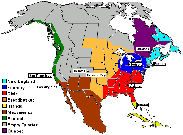
Map of the en:Nine Nations of North America, as defined by en:Joel Garreau, showing capitals. The drawing of the Nine Nation regions are based on a combination of sources, including:
Credit: KeithTyler Base outline map provided by WorldAtlas.com at [1], which includes a statement that outline maps do not need permission for use or reuse. |
| Dagsetning | 4. nóvember 2004 (original upload date) |
| Uppruni | Transferred from en.wikipedia to Commons. |
| Höfundarréttarhafi |
The original uploader was KeithTyler at enska Wikipedia. Later versions were uploaded by Cumbiadude, Habsfannova at en.wikipedia. |

|
This fictional map image could be re-created using vector graphics as an SVG file. This has several advantages; see Commons:Media for cleanup for more information. If an SVG form of this image is available, please upload it and afterwards replace this template with
{{vector version available|new image name}}.
It is recommended to name the SVG file “9nations.svg”—then the template Vector version available (or Vva) does not need the new image name parameter. |
Leyfisupplýsingar:
| Þessi skrá er með Creative Commons Tilvísun-DeilaEins 3.0 Óstaðfært notkunarleyfi. Subject to disclaimers. | ||
| ||
| This licensing tag was added to this file as part of the GFDL licensing update. |

|
Gefið er leyfi til að afrita, dreifa og/eða breyta þessu skjali samkvæmt Frjálsa GNU Free Documentation License, útgáfu 1.2 eða nýrri, sem gefið er út af Frjálsu hugbúnaðarstofnuninni með engum breytingum þar á. Afrit af leyfinu er innifalið í kaflanum GNU Free Documentation License. Subject to disclaimers. |
Original upload log
The original description page was here. All following user names refer to en.wikipedia.
- 2005-10-15 16:11 Habsfannova 619×456×8 (45277 bytes) 9nations.png (45KB, MIME type: image/png) Map of the Nine Nations of North America, as defined by Joel Garreau, showing capitals. The drawing of the Nine Nation regions are based on a combination of sources, including: * Descriptions at Nine Nation
- 2005-08-06 21:56 Cumbiadude 619×456×8 (45389 bytes) fixed teal spot at top of map (made it white like the rest)
- 2004-11-04 01:32 KeithTyler 619×456×8 (64346 bytes) Nine Nations of North America
Breytingaskrá skjals
Smelltu á dagsetningu eða tímasetningu til að sjá hvernig hún leit þá út.
| Dagsetning/Tími | Smámynd | Víddir | Notandi | Athugasemd | |
|---|---|---|---|---|---|
| núverandi | 22. maí 2007 kl. 15:58 | | 619 × 456 (44 KB) | Liftarn | {{Information |Description=Map of the en:Nine Nations of North America, as defined by en:Joel Garreau, showing capitals. The drawing of the Nine Nation regions are based on a combination of sources, including: *Descriptions at [[:en:Nine Natio |