Mynd:Prague administrative districts.png
Jump to navigation
Jump to search

Stærð þessarar forskoðunar: 776 × 600 mynddílar Aðrar upplausnir: 311 × 240 mynddílar | 621 × 480 mynddílar | 994 × 768 mynddílar | 1.056 × 816 mynddílar.
Upphafleg skrá (1.056 × 816 mynddílar, skráarstærð: 33 KB, MIME-gerð: image/png)
Lýsing
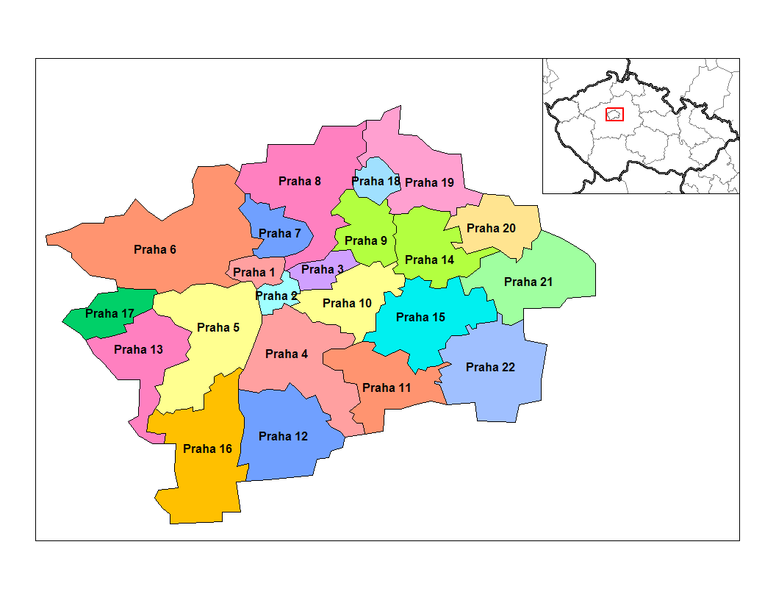
Map of the administrative districts of Prague in the Czech Republic. Created by Rarelibra 15:16, 2 January 2007 (UTC) for public domain use, using MapInfo Professional v8.5 and various mapping resources.
Leyfisupplýsingar:
| I, the copyright holder of this work, release this work into the public domain. This applies worldwide. In some countries this may not be legally possible; if so: I grant anyone the right to use this work for any purpose, without any conditions, unless such conditions are required by law. |
Breytingaskrá skjals
Smelltu á dagsetningu eða tímasetningu til að sjá hvernig hún leit þá út.
| Dagsetning/Tími | Smámynd | Víddir | Notandi | Athugasemd | |
|---|---|---|---|---|---|
| núverandi | 2. janúar 2007 kl. 15:16 | | 1.056 × 816 (33 KB) | Rarelibra | Map of the administrative districts of Prague in the Czech Republic. Created by ~~~~ for public domain use, using MapInfo Professional v8.5 and various mapping resources. |
Skráartenglar
Eftirfarandi síða notar þessa skrá: